GIS AND MAPPING
GIS (Geographic Information System) and mapping are closely related technologies that are used to capture, store, analyze, and visualize spatial data. Here’s an overview of GIS and mapping:
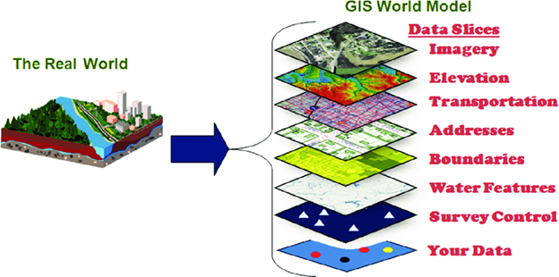
GIS (Geographic Information System):
- GIS is a system designed to capture, store, manage, analyze, and present spatial or geographic data.
- It integrates various types of data, including maps, satellite imagery, aerial photographs, GPS data, and tabular data, into a single platform.
- GIS software allows users to perform spatial analysis, such as overlaying layers, buffering, network analysis, and modeling, to derive meaningful insights and make informed decisions.
- GIS applications are wide-ranging and include urban planning, environmental management, natural resource analysis, emergency response, transportation planning, and business location analysis.
Mapping:
- Mapping refers to the process of creating visual representations of spatial data, often in the form of maps, charts, graphs, or 3D models.
- Maps can be created using GIS software, which enables users to combine and symbolize spatial data layers, add labels, legends, and annotations, and customize the appearance of the map.
- Mapping can be static (printed maps, PDFs) or interactive (web maps, mobile apps) and is used for communication, analysis, and decision-making purposes.
- Mapping techniques include thematic mapping (showing data patterns or distributions), topographic mapping (depicting elevation and terrain features), and cartographic design (creating visually appealing and informative maps).
Key Components and Functions:
- Data Collection: GIS and mapping require data collection from various sources, including surveys, satellite imagery, GPS devices, and remote sensing technologies.
- Data Management: GIS systems organize and store spatial data in databases or file formats, enabling efficient data retrieval, editing, and sharing.
- Data Analysis: GIS tools enable spatial analysis, such as spatial queries, proximity analysis, spatial statistics, and modeling, to uncover patterns, relationships, and trends in the data.
- Data Visualization: Mapping tools within GIS software create visual representations of spatial data, including maps, charts, graphs, and 3D models, for better understanding and communication.
Applications:
- GIS and mapping find applications in diverse fields such as urban planning, land use management, environmental conservation, disaster management, public health, transportation, agriculture, real estate, and telecommunications.
- They help in decision-making, resource allocation, spatial planning, risk assessment, asset management, and monitoring of changes over time.
In summary, GIS and mapping are powerful tools for managing, analyzing, and visualizing spatial data, enabling users to gain insights, solve problems, and make informed decisions across various disciplines and industries.